I’ve been asked to do a lovely task: play the game of Herodotus the historian. What a good thing too, for history is nearly as important as fairytales, concealing the world’s essence within. But because the books I read on the subject were voluminous and the game was meant to be short, I had to trim down the history of Romania and take the golden path of brevity.
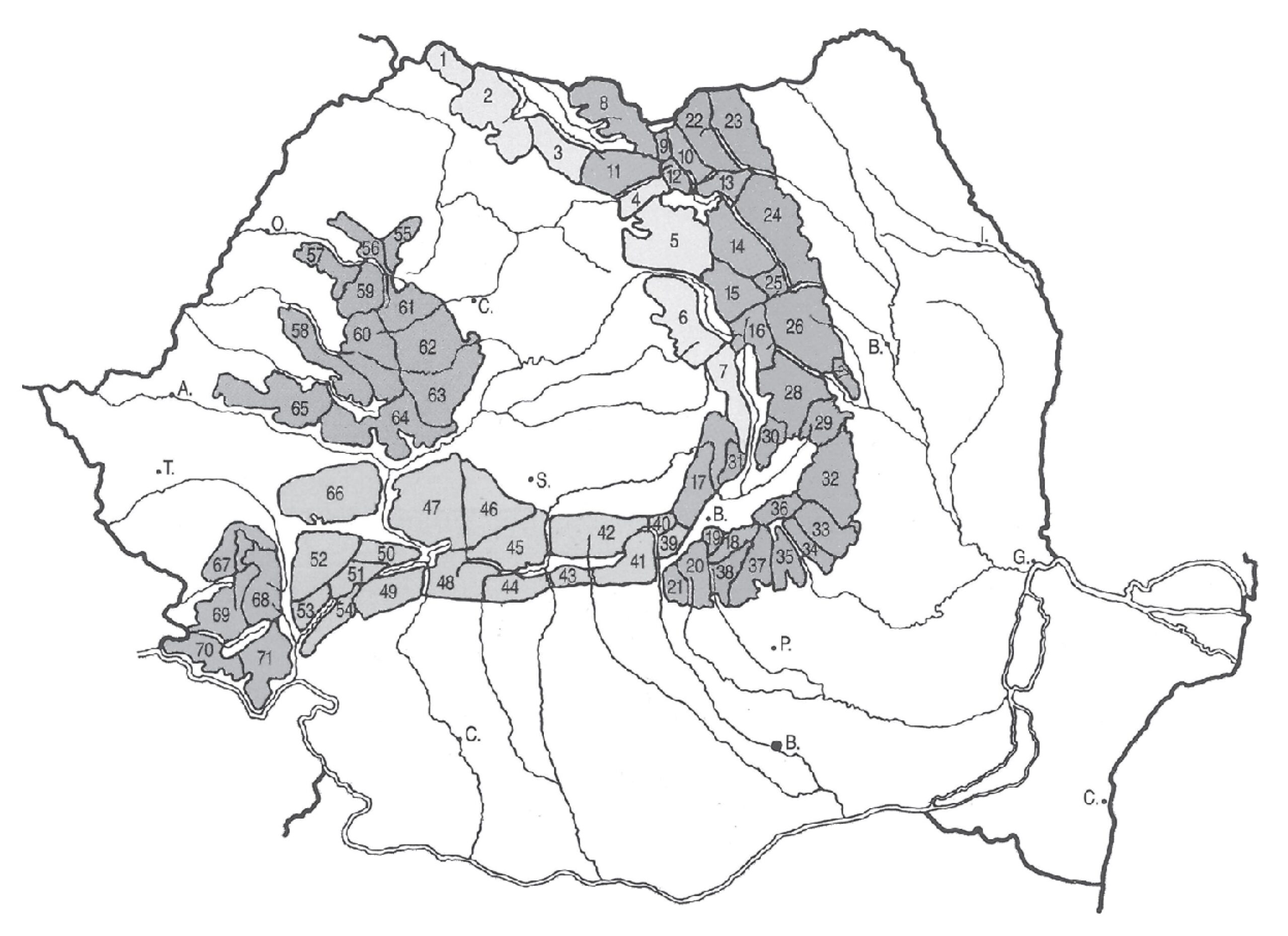
DACIA. Land of the Dacians, an Indo-European people that emerged in this part of Europe from Neolithic mists and, after much blending with other tribes and nations, has remained here to this day. Historians officially call them Geto-Dacians, though it is not certain if they were originally two related tribes (like the Dudlebs and the Luchans) or if they are one and the same nation, called differently by Romans and Greeks. They were descendants of the northern branch of Thracians who flooded the entire Balkan region thousands of years ago. Centuries passed and the Thracian king, Burebista, tried to unite all the Geto-Dacian tribes (among them the Carpi, after whom the Carpathians take their name) that resided in the territory of modern-day Romania into a sovereign and independent Dacian state. He succeeded for a time, but not all Dacians were happy with the centralizing tendencies, and in 44 B.C., Burebista was assassinated and the state fell. Around that time, the Dacians first encountered the Roman Empire, which had by then established the province of Moesia south of the Danube River. Greek colonization of Romania’s Black Sea region had begun three-quarters of a millennium earlier with the harbors of Istros (today called Histria) established at the mouth of the Danube in the 7th century B.C., Kallatis (Mangalia) in the 6th century, and Tomis (Constanţa) in the 5th century. The Dacians were a warlike people, and so were the Romans. Decebal, leader of the Dacians re-formed and lead the Dacian state between 87 and 106 AD, establishing Sarmizegetusa in the Orăştie Mountains as the religious and political capital. An era of wars had come. At first, the Romans seemed to be losing, then they got the upper hand. Despite Emperor Domitian’s victory in 88 AD, and Trajan’s in 102 (see the Adamclisi monument in Dobrogea), Dacia remained unconquered. The Romans built a bridge over the Danube at the Iron Gates and defeated the mountain city of Sarmizegetusa in 106 AD during the Second Dacian War. As a result, Decebal fell on his own knife, and the Dacian state became a Roman province for the next 169 years. The Romans were skillful colonizers and 40 km southwest of the Dacian capital, they established another city also called Sarmizegetusa (today a Roman archeological dig). They founded other towns and settlements as well, mined for gold, imported citizens from all across the empire and settled war veterans. This brought about a unified language: vulgar Latin, which to this day, remains the language of Romania (enriched by Slavic and Germanic expressions, and the remnants of the now-extinct Dacian tongue). Român – Roman. But the rest of the uncolonized Dacians, along with other invading tribes so vexed the province that by the year 272, or more precisely 275, the Romans had left completely. Of all of Dacia, only Dobrogea remained part of Rome, and today’s Romanians can take pride in their ancestors’ heroic past, the most glorious time in their history.
WALLACHIA. One of the three major geographical regions in present-day Romania, it stretches from the Carpathians to the Danube, divided by the Olt River into Oltenia or Lesser Wallachia (west of the river) and Muntenia, Greater Wallachia (east of the Olt). The origins of the name are Germanic since, for the Teutons of the time, the word Wallachian was synonymous with the word Vlach and used for all Romanic tribes. I shall now attempt to bridge swiftly the nearly ten centuries that separate the departure of the Romans from Dacia and the establishment of the first principalities of Wallachia, Moldavia, and Transylvania, though history has not been overly forthcoming in this regard. After the end of Roman domination, the Dacians, by far the most numerous ethnic group in the region, lived in commons initially with shared property, herds and fields. The Migration Period had a profound influence on the land lying between the Carpathians and the Black Sea since, from about the 4th century AD, innumerous tribes, with names almost mythical, settled or passed through the region: Ostrogoths, Visigoths, Huns, Gepids, Avars, Lombards, Slavs, Bulgarians, Hungarians, Pechenegs, and Cumans (Polovtsians, Kipchaks) after which Romania was often called Black Cumania between the 10th and 13th centuries. For a time, the territory of Romania belonged to the Kievan Rus (northern Moldavia), then to the Principality of Halych, then to the Bulgarian Empire, falling subsequently under Byzantine influence; it was ruled by both Tartars and Hungarians. Today’s Romanians are a combination of mainly Dacian blood mixed with all the tribes above that speak the Roman tongue.
The modern-day region of Wallachia became a principality in the 12th century, and in 1324, ruler Basarab I threw off Hungarian domination, bringing independence to the land. The capital city was Curtea de Argeş which still stands today at the south-facing base of the Făgăraş; Bucharest became the capital much later, established as such by the Turks for its location: resting in the flatlands it was difficult to defend. From the end of the 14th century to the year 1878, the Turks were the main actors in this region of Europe. Though the Wallachian Voivode, Mircea the Elder, (whose illegitimate son was notorious Vlad the Impaler, or Dracula) defeated them in 1394, the Turks soon returned to the Balkans, flooding all of southeast Europe. For centuries, Wallachian (as well as Moldavian and Transylvanian) voivodes, boyars magnates and aristocrats were forced to tack between the Turks (in 1545, Wallachia became a vassal state of Turkey, but was initially largely autonomous) and their enemies the Russians, Austrians, and Hungarians. Often divided, they were bloodily defeated in countless uprisings, battles, and rebellions (e.g. Oltenia belonged to Austria for part of the 18th century, etc.). After numerous uprisings, the Turks revoked the autonomy of the local nobility (or “boyars”) and between 1715 and 1821 (1711 in Moldavia) installed Phanariots – rulers of Greek origin named for Phanar, the quarter of Constantinople they came from. They guaranteed that the heavy imperial taxes the Turks (otherwise benevolent toward the religions and liberties of occupied nations) exacted on their vanquished territories would be duly collected and delivered.
Ever more similar political fates with neighboring Moldavia led, in 1859, to the establishment of a personal union between the principalities of Wallachia and Moldavia under Moldavian prince Cuzou and, in 1869, to the unification of both lands, as yet subject to weakening Turkish influence and growing Russian might, into the principality of Romania.
Wallachian influence even stretched as far as Moravia. From about the 12th century, they moved gradually with their herds along the Carpathian arc up to the northernmost edge of the Carpathians in Slovakia and Moravia (Wallachian colonization) where they blended with the local inhabitants, leaving many residual Romanian herdsman expressions.
MOLDAVIA. Named for the Moldova River, it originally stretched between the rivers Siret and Dniester, and in days of old was sometimes referred to as Multania. Western Moldavia spreads between the Carpathian Mountains and the river Prut (which formed a boundary with the former USSR), while eastern Moldavia, also called Bessarabia (apparently for the Thracian Beser tribe [1] that once inhabited the region), lies betwixt the Prut and the Dniester, and after the fall of the Soviet Union in 1991 became part of the Commonwealth of Independent States, which included the Pridnestrovian and Gaugaz Republics, [2] with the capital city in Kishinev. Moldavia is a fertile land that has historically belonged to, or at least fallen under, the dominance of Russia, Poland, Austria, Hungary, and Turkey. In 1538, the kingdom that had been established there in the 14th century became a vassal of the Ottoman Empire. Famous voivodes of the region include Dragoș, Alexander the Good, Stephen the Great, and Petru Rareș. In the 15th and especially 16th centuries, Eastern Orthodox architecture (Moldavian monasteries) blossomed in the region. For many years, the capital city was Suceava but was later moved to Iaşi. As in Wallachia, the land was swept by conflicts between boyars, voivodes, and their Turkish occupiers, while a segment of Moldavia (see Bukovina) remained in Austrian hands between 1774 and 1919 after they defeated the Turks. A source of constant friction between Moldavia and the neighboring Russian Empire was Bessarabia, which Russia occupied several times in 1787, 1812, 1829, and as part of a treaty after expelling the Turks in 1878. After World War I, however, Bessarabia fell to Romania (over 50 percent of the population was Romanian), but the annexation was not recognized by the Soviet Union which, first in 1940, and then definitively after the Second World War made it a part of the Moldavian Soviet Socialist Republic. In 1861, the principalities of Wallachia and Moldavia united in the principality of Romania.
TRANSYLVANIA. A land embraced from the south, east, and west by the Carpathian arc. After which seven castles it takes its name I have not discovered. [3] Though perhaps it comes from the old name for the present-day town of Sibiu – Sibinburg. The Romans called the region Transsilvania (an important mining area in their province of Dacia), which means “Land beyond the forest”, beyond Carpathian walls, Hungarians used the name Edély (pronounced approximately “erday”), Romanians Ardeal, and Germans Siebenbürg. For centuries, Romans, Hungarians, Germans, Austrians, and Turks struggled to dominate the region, and it was not until 1919 that Romanians were finally victorious. Even the illustrious former crown city of Transylvania was known by many names in many tongues: Latin – Apulum, German – Karlsburg or Weissburg, Hungarian – Gyula Fehérvar, Czech – Karlův Bělehrad, Romanian – Alba Iulia. Transylvania fell under Hungarian influence in the 12th century as an independent principality or voivodeship in the Kingdom of Hungary, and as such, was afforded its own parliament and voivodes (magnates). This status continued until 1541 when it was taken over by Turks whom Transylvanian voivode Jan Hunyady had successfully repelled in 1456. The Turks chose a more moderate form of occupation and Transylvania became an “autonomous principality under the suzerainty of the Porte” (Porte = the name for the gate to the palace of the sultan, later a name for the Ottoman Empire). Austria and Hungary alternated in dominance over the region, one side uniting with the Turks against the other; Transylvanian nobles, too, were split, some favoring the Turks, others the Hapsburgs. At the start of the 16th century under Voivode Jan Zápolský, the principality expanded its territory to include eastern Slovakia and the town of Košice, while under Voivode Báthory, Transylvania united with the Polish Empire. The land was inhabited by four nationalities: Hungarians, Germans (brought in as colonizers from various parts of Germany, especially Saxony, by King Géza II in the 13th century) Szekelys (descendants of Hungarians and older Turkish tribes) and native Romanians who, though far more numerous, had no political power. Between 1686 and 1699 after Turkey’s defeat, Transylvania gradually fell under definitive Austrian control, bringing about what are known as the kuruc [4] uprisings (kuruc = forces of Hungarian nobleman Francis II Rákóczi who led the anti-Hapsburg rebellions). The situation in Transylvania, however, changed very little overall and, with an ever-growing national awakening of Romanians and not a few uprisings (in the Western Carpathians for example), Transylvania remained part of Austro-Hungary until its collapse in 1919 whereupon it was given to Romania. And there, aside from the Hungarian occupation of 1940-1944, it remains even today.
BANAT. A flat fertile region between the Lower Tisza, Mureş, and Carpathian Mountains. The name is derived from the word “ban,” a high-ranking military governor in charge of provinces in the southern reaches of Hungarian lands. It was completely destroyed during the Ottoman wars and resettled in the 18th century by Serbs, Romanians, Slovaks, Czechs, and Germans after the expulsion of the Turks. Upon falling into Turkish hands in 1552, the former Hungarian region was renamed Temesvár pashalik (pashalik = territory governed by a pasha or local ruler who answers directly to the sultan) called for its capital city – Banat. The northern part was later renamed the Pashalik of Varat (after the city of Oradea). In 1699, the Turks were expelled from Hungary and Transylvania (following the Treaty of Karlowitz) but still clung to Banat; after two more wars with Austria, they would lose that too succeeding the Treaty of Passarowitz in 1718. Banat remained under Austrian military rule until 1751, and subsequent civilian governance was administered mainly by Hungary, though between 1849 and 1860, this responsibility fell to Austria. Banat became part of Romania in 1919, while the western segments between the Tisza and Danube Rivers (called Vojvodina) were forfeited by Austro-Hungary to the newly formed Yugoslavia, or more precisely, Serbia.
BUKOVINA. The northwestern area of the former Principality of Moldavia, it was acquired by the Austrian Empire in 1775 following victory over the Turks. Though at first a part of Galicia, it became a nominal duchy within the Austrian Empire in 1849. Although the name Bukovina is quite new, wooded areas along the Moldavian-Polish border had been commonly called that since the 15th century. In 1919, the region was turned over to Romania (with the exception of four Polish municipalities), including the capital city of Chernivtsi. After the Second World War, the region’s northern area was annexed by the Ukrainian SSR, and what was left remained part of Romania. About a third of the population of Bukovina is made up of Hutsuls and Rusyns.
DOBRUDJA. A grassland region between the Danube and the Black Sea. Dobrogea in Romanian, a name hearkening back to 14th-century Bulgarian boyar Dobrotitsa. Essentially uninhabited till the end of the 19th century, it was a corridor for countless war parties, conquests, and migrations. A narrow strip of coastland was colonized by the Greeks in the 7th century B.C. (harbors of Istros – Histria, Kallatis – Mangalia, Tomis – Constanţa). Despite the Romans withdrawing from Dacia, they continued to cling to Dobrudja (part of the province of Moesia they called Scythia Minor after the ancient inhabitants of the region). Until the 14th century, the territory was part of the Bulgarian Empire and its battle for regional influence against the Eastern Roman Empire [5] and the Cumans. After that, the Turks occupied the region, and it became the Sanjak of Dobrudja (lying within the Pashalik of Rumelia) for centuries to come. In 1878, after the defeat of the Ottomans, much of Dobrudja was ceded to Romania through the Treaty of Berlin, though a small segment also fell to Bulgaria. As a result, from 1912-1919 conflicts arose between the two countries (each occupying the other’s territory), but Romania succeeded in clinging to its part of Dobrudja and the Black Sea coast.
ROMANIA. Became a country in 1861 through the uniting of Wallachian and Moldavian principalities (though Wallachian voivode Michael the Brave, or Mihail Viteazu, briefly united Wallachia, Moldavia, and Transylvania to fight off the Turks at the start of the 17th century). After lengthy talks, Moldavian prince Colonel Cuza [6] was chosen as the first unifying ruler of the Romanian principality. However, in 1866 he was forced, by mounting interior and international pressures, to pass governance of Romania to the foreign rule of Karl von Hohenzollern-Sigmaringen. A year prior to the 1878 expulsion of the Ottomans, which largely succeeded due to assistance from the Russian army, the Principality of Romania proclaimed itself a kingdom (ratified by its parliament in 1881), and Prince Karl von Hohenzollern-Sigmaringen became King Carol I, who ruled until his death in 1914. He was succeeded by his nephew, Ferdinand who, after two years of hesitation, joined the allied forces (England, France, etc.) in 1916 in declaring war on the Austro-Hungarian Empire and Germany, thus entering World War I. Though Romania was swiftly defeated and three-quarters occupied by enemy forces, the Romanians heroically defended their last stronghold in Moldavia, and after the war, the Allies declared that by halting the onslaught of enemy forces, the Romanians had shortened the war by several weeks, perhaps months. As a result, in 1919 Transylvania, Banat, Bukovina, and Bessarabia were ceded to Romania, doubling its territory and number of citizens. Rather astonishingly, when King Ferdinand I died in 1927, his son Carol forfeited the throne to his six-year-old son Michael (and an appointed regency) and departed the country. Not until 1930, satiated by the western bon vivant lifestyle, did he return to rule Romania as King Carol II. His reign was not a happy one, however, and in 1938 he transformed what was a constitutional monarchy into an ever-deepening dictatorship. The eight previous years had been spent cooperating with the Gardă de Fier, or Iron Guard, a fascist movement and political party that first terrorized communists, then Hungarians and Jews, and finally the Romanian population itself. After initially attempting to join forces with them, the king began violently suppressing the group, even having their leader, Codreanu, shot “while escaping.” Unsurprisingly, the Gardă reacted with assassinations and ever greater terror in the streets. With the start of World War II in 1940 and the Hungarian occupation of Transylvania, Carol II lost control of the political situation at home and decided to emigrate for a second time. Before his departure, he formally conferred kingship to his son Michael, though real power and the title of Conducător – Leader of the State – was held to General Antonescu, war hero of the First World War. He, too, proved unsuccessful in fully mitigating the murderous Iron Guard, later joining forces with them because of shared sympathies for Hitler’s Germany. Side by side with Germany, Romania joined the assault of the Soviet Union in June 1941. Despite re-occupying Bessarabia, which the Russians had taken in 1940, their army suffered heavy casualties across the Russian Front. A day after the Red Army victoriously crossed into Moldavia, Romania erupted in anti-government, anti-German rebellion (August 23, 1944) [7]. At King Michael’s command, Antonescu was arrested and a democratic government appointed. However, democracy lasted less than a year, and at Moscow’s orders, a communist government, with Petru Groza at its head, was established. A 1945 attempt at returning to democracy was violently suppressed by the ruling communists, and a mock trial of General Antonescu was held where he was sentenced to death and shot on June 1, 1946. On the thirtieth of December 1947, the monarchy was dismantled, Romania was proclaimed a people’s republic, and King Michael I left the country. Forty-two years of brutal communist rule later and following a week of bloodbaths and murders perpetrated on the citizen population, the last dictator of Romania, Nicolae Ceauşescu, was shot and killed along with his wife on Christmas of 1989. This land of bankrupt economic and moral relationships has been struggling to return to civilized life since 1990. Evidence of this can be seen in the return of King Carol II’s remains from Portugal in 2003, where he died in 1953. Additionally, his son, King Michael I was allowed to repatriate in 2002 after living in emigration in Switzerland, and all his property was returned.
Romania became a NATO member on March 9, 2004 and joined the European Union on January 1, 2007. It currently remains outside the so-called Schengen Area.
[1] Translator’s note: Current scholarly research suggests Bessarabia was named after the Wallachian Basarab Dynasty which ruled the region during the 14th century.
[2] Translator’s note: The Pridnestrovian and Gaugaz Republics are referred to together as the Pridnestrovian Moldavian Republic; it is an unrecognized breakaway state within the country of Moldova.
[3] The Czech word for Transylvania, “Sedmihrady”, is a translation of the German “Siebenbürgen” or “Seven Castles”, a name commonly used for the region in other Slavic languages as well.
..
[4] Pronunciation: “koorootz”
[5] Also called The Byzantine Empire.
[6] Alexander Iona Cuza – Prince of Moldavia, Prince of Wallachia and Domnitor of Romania.
[7] King Michael I, son of Carol II, led a coup against Conducător Antonescu.